

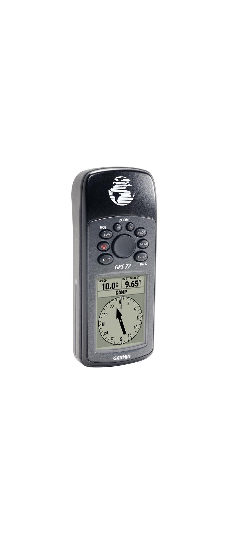

Garmin GPS 72 Handheld GPS Unit
Garmin GPS 72 Handheld GPS Unit
Mariner-friendly, the Garmin GPS 72 Handheld GPS Unit is a low-cost entry-level solution for land or marine navigation.
The GPS 72 is designed to provide precise GPS positioning using correction data obtained from the Wide Area Augmentation System (WAAS). When using WAAS corrections, the GPS 72 is accurate to within 3 metres.
Important data is right at your fingertips, as the Garmin GPS 72 Handheld GPS Unit is preloaded with worldwide cities as well as marine navigation aids including lights, buoys, sound signals and day beacons.
Into boating, hunting or fishing? The GPS 72 features built-in celestial data including tide information, sunrise/sunset times and a hunting and fishing calendar.
Whether on land or on the water, the GPS 72 can save up to 500 of your favourite places in memory and point you to your destination
Don't worry about losing this GPS device in the drink. The GPS 72 is IPX7 waterproof. meaning it can withstand an accidental dunk or splash in the lake. Don't worry about diving in to get it either as the GPS 72 will float on the surface, making it easy for you to fish out.
Rugged, waterproof and unsinkable, the GPS 72 offers a large, 4-level greyscale screen, providing excellent handheld navigation for your land and sea adventures.
GPS 72 Features Include
- Built-in quad helix receiving antenna
- High-contrast FSTN, 4-level grey scale (120 x 160 pixels) display
- Backlit display and keypad
- Permanent user data storage; no memory battery required
- Water resistant, IEC-529, IPX7 (submersible 1 m @ 30 minutes) and floatable
- 500 user waypoints with name and graphic symbol; 50 reversible routes
- Position formats include Lat/Lon, UTM, Loran TDs, Maidenhead, MGRS and user grid
- Audible alarms for anchor drag, arrival, off-course, proximity waypoint and clock
- 'Large numbers' option for easy viewing
- 1 MB internal memory for loading MapSource Points of Interest data
- Trip computer provides odometer, stopped time, moving average, overall average, total time, max speed and more
- Automatic track log; 10 saved tracks let you retrace your path in both directions
- Course and speed filtering
- Tide Tables
- Area Calculation
- Built-in celestial tables for best time to fish, plus sun and moon calculations
Physical and Performance
- Unit Dimensions (WxHxD): 6.9 x 15.7 x 3.0 cm
- Display Size (WxH): 4.1 x 5.6 cm
- Display Resolution (WxH): 120 x 160 pixels
- Display Type: 4 level grey LCD
- Weight: 218 g with batteries
- Battery: 2 x AA batteries (not included)
- Battery Life: 16 hours
- Serial Interface
Maps and Memory
- 500 Waypoints/Favourites/Locations
- 50 Routes
- Track Log: 2,048 points/10 saved tracks
Unavailable