

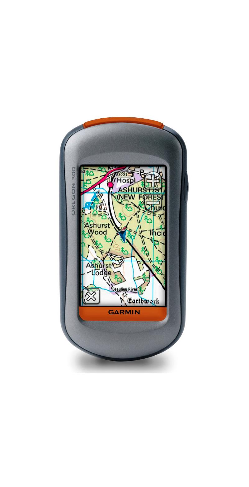


Garmin Oregon 300 WW + Garmin GB Discoverer 1:50 National Parks Ordnance Survey Map
The Garmin Oregon 300 WW Handheld GPS Unit puts the great outdoors at your fingertips - and here it is now combined with Garmin's GB Discoverer 1:50 National Parks map that brings Ordnance Survey mapping quality to your handheld device.
This next-generation handheld features a rugged touchscreen along with a built-in basemap with shaded relief, a high-sensitivity receiver, barometric altimeter, electronic compass, microSD card slot, picture viewer and more.
This unit even allows you to exchange tracks, waypoints, routes and geocaches wirelessly between similar units.
Touch and Go
Oregon 300 leads the way with a tough, 3-inch diagonal, sunlight-readable, colour touchscreen display. Its easy-to-use interface means you’ll spend more time enjoying the outdoors and less time searching for information.
Both durable and waterproof, Oregon 300 is built to withstand the elements. Bumps, dust, dirt, humidity and water are no match for this rugged navigator.
Explore More
Oregon 300 comes with a built-in worldwide basemap with shaded contours. Simply touch the colour screen to navigate. Its digital elevation maps show you shaded contours at higher zoom levels, giving you a big picture of the surrounding terrain.
Share Wirelessly
With Oregon 300 you can share your waypoints, tracks, routes and geocaches wirelessly other Oregon and Colorado users. Now you can send your favourite hike to your friend to enjoy or the location of a cache to find. Sharing data is easy. Just touch 'send' to transfer your information to similar units.
Find Fun
Oregon 300 supports Geocaching.com GPX files for downloading geocaches and details straight to your unit. No more manually entering coordinates and paper print outs! Simply upload the GPX file to your unit and start hunting for caches. Show off photos of your excursions with Oregon’s picture viewer. Slim and lightweight, Oregon is the perfect companion for all your outdoor pursuits.
Keep Your Fix
With its high-sensitivity, WAAS-enabled GPS receiver and HotFix satellite prediction, Oregon 300 locates your position quickly and precisely and maintains its GPS location even in heavy cover and deep canyons. The advantage is clear — whether you’re in deep woods or just near tall buildings and trees, you can count on Oregon to help you find your way when you need it the most.
Get Your Bearings
Oregon 300 has a built-in electronic compass that provides bearing information even while you're standing still, and its barometric altimeter tracks changes in pressure to pinpoint your precise altitude. You can even use the altimeter to plot barometric pressure over time, which can help you keep an eye on changing weather conditions.
Add Maps
Conveniently plug in optional preloaded microSD cards for all your outdoor activities on land or water. Just insert a MapSource card with detailed street maps, and Oregon provides turn-by-turn directions to your destination. Add select topographic maps to take advantage of Oregon’s 3-D map view which gives you a better perspective of your elevation.
With BlueChart g2 Vision, you’ll get everything you need for a great day on the water including depth contours, navaids and harbours. The card slot is located inside the waterproof battery compartment, so you don't have to worry about getting it wet.
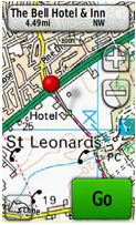 |
Dynamic Search The traditional look and feel of the Ordnance Survey map detail complements Garmin topographic maps dynamic search. Use Garmin to search, select and navigate to points of interest and postcodes and follow the route on foot, in the car or by bike on the OS Explorer Map backdrop. |
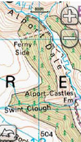 |
Rich Mapping Detail Ordnance Survey's mapping contains rich topographic data to aid your navigation. With rights of way, fences, permitted paths, contours and bridleways, discover new destinations and geographic references on foot, bike or in the car. |
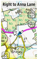 |
Turn-by-Turn Navigation Once you've chosen your National Park destination, get there on the road with Garmin. Every Garmin topographic map contains whole-of-Britain 1:250k scale Ordnance Survey mapping to help you plan the journey and navigate there turn by turn. |
Specification
- Physical & Performance:
- Unit dimensions (WxHxD): 2.3 x 4.5 x 1.4 inches (5.8 x 11.4 x 3.5 cm)
- Display size (WxH): 1.53 x 2.55 inches (3.8 x 6.3 cm); 3-inch (7.6 cm) diag
- Display resolution (WxH): 240 x 400 pixels
- Display type: Transflective colour TFT touchscreen
- Weight: 6.8 oz (192.7 g) with batteries
- Battery: 2 x AA batteries (not incl); NiMH or Lithium recommended
- Battery life: 16 hours
- Waterproof: Yes (IPX7)
- Floats: No
- High-sensitivity receiver: Yes
- Interface: USB
- RoHS version available: Yes
- Maps & Memory:
- Basemap: Yes
- Pre-loaded maps: No
- Ability to add maps: Yes
- Built-in memory: 850 MB
- Accepts data cards: microSD card (not included)
- Waypoints/favourites/locations: 1000
- Routes: 50
- Track log: 10,000 points, 20 saved tracks
- Features:
- Automatic routing (turn-by-turn routing on roads): yes (with optional mapping for detailed roads)
- Electronic compass: Yes
- Barometric altimeter: Yes
- Geocaching-friendly: Yes (paperless)
- Outdoor GPS games: Yes
- Hunt/fish calendar: Yes
- Sun and moon information: Yes
- Tide tables: Yes
- Area calculation: Yes
- Custom POIs (ability to add additional points of interest): Yes
- Unit-to-unit transfer (shares data wirelessly with similar units): Yes
- Picture viewer: Yes
- Additional: Touchscreen: Yes
Unavailable