


ViewRanger - Mobile Phone Mapping Software - Great Britain National Parks 1:50,000
ViewRanger - Mobile Phone Mapping Software - Great Britains National Parks 1:50,000
Map Coverage: Ben Nevis, Brecon Beacons, Pembrokeshire Coast, Cairngorms, Dartmoor, Lake District, Loch Lomond and The Trossachs, New Forest, Norfolk Broads, North York Moors, Northumberland, Peak District, Snowdonia, South Downs and Yorkshire Dales
ViewRanger is a unique mapping, navigation, tracking and information tool for mobile phones that provides information about your immediate surroundings through a natural and intuitive display. ViewRanger transforms your iPhone* or your Android or Symbian based smartphone into a fully featured trail navigation system (*upload not available through this site).
ViewRanger is ideal for tourists, walkers, cyclists, mountain bikers, horse riders, geocachers, river boaters - in fact, anyone who enjoys the outdoors.
ViewRanger is used by outdoor enthusiasts and occasional tourists alike. Dedicated GPS receivers are typically expensive and offer only a basic map display with limited information and no connectivity. ViewRanger is the first solution to combine high-quality topographic maps, off-road GPS navigation, panoramic viewpoint maps and location-based content sharing in an integrated, simple-to-use application running on smartphones.
There is a wide range of maps available with ViewRanger. The software comes pre-installed on a microSD Card so you can simply plug in and go!
 |
 |
|
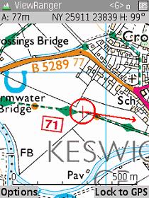
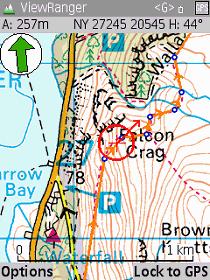
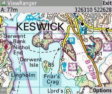
MAP:Clear and detailed topographic maps (sourced directly from National Mapping and Geoscience Agencies) provide detailed topographic map information including hill contours, tourist information, camping and caravan sites, picnic areas, viewpoints and footpaths. Control what you display with fast map pan and zoom controls. |
LOCATE:Using the phone's internal GPS, ViewRanger will plot your position and update the map automatically as you travel (or on Symbian phones you can use a Bluetooth GPS.) Your velocity and direction indicator are shown on the moving map display. Your current location grid reference is displayed at the top of the screen. You can choose from a range of formats including 6-, 8- or 10-digit grid reference, National Grids, UTM and various forms of longitude/latitude. |
|
 |
 |
|
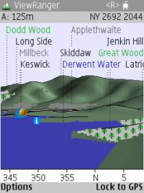
IDENTIFY:Unique 3D Panoramic Viewpoint Maps show you what you see! Includes thousands of Features of Interest identified and labelled on Panoramic Viewpoint Map. †The panorama is available now on Symbian, coming soon to Android and iPhone. |
NAVIGATE:Navigate along routes or to any waypoint or point of interest. Create and edit routes and waypoints on your phone or import from popular PC software applications and websites.† |
|
 |
 |
|
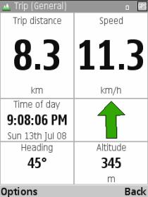
GPS:Navigate with map or a traditional GPS display showing position, altitude, bearing, distance and ETA to target, velocity and route XTE. You can even have it notify you with an audible alarm when you are nearing your target or waypoint along a route.† TRIPVIEW:Monitor key information whilst on the move. User-definable screen layouts lets you customise TripView to show the data you need. Includes speed monitor, distance, pace and much more.† |
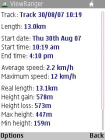
REVIEW:Record a Track Log so that you can review your performance, including parameters such as time taken, maximum and average speed, track length and height gain/loss. Brilliant for runners and cyclists. |
|
 |
 |
|
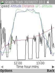
ANALYZE:Review and analyze your performance with on-screen graphs both during and after recording your tracklog. Export your tracks as GPX files for import into Google Earth and other applications.† |
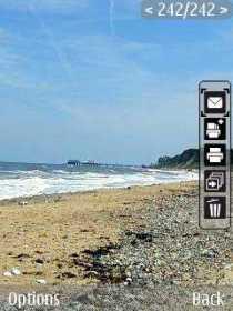
RECORD:ViewRanger integrates with your smartphone's camera to quickly and simply record photos and video clips onto the map. Whether you are taking holiday snaps, want to record wildlife sightings or just want to remember where you took a particular video clip - ViewRanger makes it simple.† |
|
 |
||
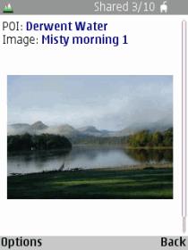
CONNECT:Share your experiences by associating photos and text notes with landscape features and publishing to the ViewRanger online Information Exchange. View and read other people's postings.† |
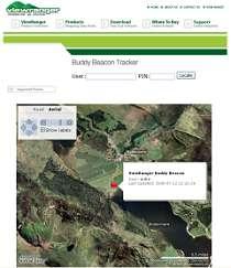
BUDDY BEACON:See your friend's location on-screen or publish your location to specific friends and family to see on their handsets ... |
|
 |
 |
|
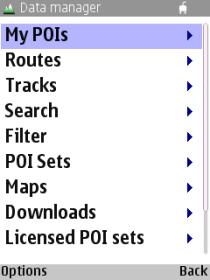
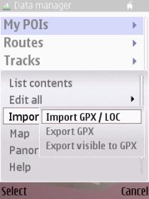
MANAGE:ViewRanger includes a Data Manager to make it easy to manage your routes, tracks, waypoints, POI and maps. It's easy to bookmark locations so that you can revisit your favourite locations at any time. |
... or view on the web through the Buddy Beacon portal. |
|
 |
 |
|
EXCHANGE:Route import lets you to bring in routes as GPX files from third-party web sites and PC route-planning software. POI import allows you to incorporate Points of Interest databases from third parties. Are you a geocacher? ViewRanger imports GPX and LOC files Export your tracklogs to your PC for further analysis.† |
PUBLISH:Publish your TravelLog photos instantly through your Facebook profile by adding the ViewRanger for Facebook application to your Facebook profile page. As soon as you Share a photo from ViewRanger on your phone, it will appear in your Facebook ViewRanger TravelLog.† |
|
 |
†All the features listed above are available now on Symbian based phones. Some features are not yet available on Android and iPhone, but are coming soon in free updates. The panorama, navigation, graphs, photo marking and exchange are not yet available on Android and iPhone. GPX import and export is not yet available on Android. *For a list and information on compatible phones for ViewRanger, click on 'Additional Information' link beneath 'Add to Basket' above.* |
|
DISPLAY:ViewRanger supports all screen sizes and viewing orientations.
|
|
Unavailable