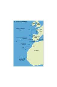
Imray Iolaire E Series Charts for the Atlantic Islands
Imray Iolaire Charts for the Atlantic Islands provide coverage of popular areas on sheets especially designed for the needs of yachtsmen. Many of the charts in the series now include sailing directions on the reverse side.
Each Imray lolaire Chart provides ideal coverage of familiar cruising grounds at workable scales. Large scale plan inserts cover harbours and anchorages in detail. A single Imray lolaire Chart does the work of several of its rivals.
Produced by Imray Laurie Norie & Wilson Ltd in the United Kingdom, publishers of nautical charts since the 18th century. Imray lolaire Charts were first launched in 1979 and are produced to the high standard that has come to be associated with the oldest private chart publisher in the world.
Each sheet is printed on durable waterproof paper, which is ideal for charter boats where wear and tear is considerable.
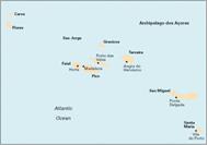
E1 - Arquipelago dos Açores, 1:750 000 - Plans included: Vila das Lajes, Horta, Lajes (Pico), Porto das Velas, Vila da Praia, Praia da Vitória, Angra do Heroísmo, Ponta Delgada, Vila Franco do Campo, Vila do Porto. 2011 Edition - Fully updated throughout. This edition shows extensive harbour developments (including new marinas) on the Vila das Lajes, Horta, Porto das Velas, Vila da Praia, Praia da Vitória and Ponta Delgada plans. The inset for Vila Franco do Campo has been redrawn with new survey data and is now fully WGS84 compatible. In addition, a new plan of Lajes (Ilha do Pico) has been added in place of Madalena.
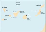
E2 - Islas Canarias, 1:600,000 - Plans included: Puerto de Santa Cruz, Puerto de la Estaca, Puerto de San Sebastian de la Gomera, Darsena de Los Llanos (Marina Santa Cruz), Darsena Pesquera (Marina Tenerife), Puerto de las Palmas, Morro Jable, Marina Rubicon, Puerto Calero, Estrecho del Rio. 2011 Edition - Fully updated. Includes changes to depths and coastline at Dársena de los Llanos and Dársena Pesquera. The Puerto de las Palmas plan has been extended and fully updated to show the extensive harbour developments. In addition, a new plan of Puerto Calero replaces the Puerto del Rosario plan.
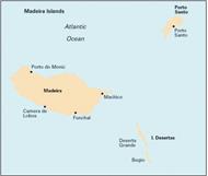
E3 - Arquipelago da Madeira, 1:170,000 - Plans included: Porto Santo, Porto de Recreio de Calheta, Funchal, Ponta de Sao Lourenco, Quinta do Lorde, Enseada da Doca (Isla Deserta Grande), Porto de Machico, Agua de Pena. Plans on reverse of chart: Selvagem Grande, Selvagem Pequena. 2011 Edition - Extensively reschemed to include new plans of Quinta do Lorde, Enseada da Doca, Porto de Machico and Agua de Pena. Sailing directions have been added to the reverse of the chart, as well as plans of Ilhas Selvagens.
E4 - Arquipelago de Cabo Verde, 1:500,000 - Plans included: Porto Novo (Ilha de Santo Antão), Porto Grande (Ilha de São Vicente), Ilha de Santa Luzia, Porto de Tarrafal (Ilha de São Nicolau), Porto da Preguiça (Ilha de São Nicolau), BaÍa da Palmeira (Ilha do Sal), Porto de Sal-Rei (Ilha da Boavista), Porto da Praia (Ilha de Santiago), Cavaleiros (Ilha do Fogo), Porto da Furna (Ilha Brava). 2011 Edition - This is a brand new, digitally drawn edition of the chart, offering improved clarity and enhanced definition of detail.
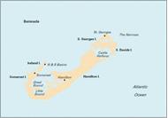
E5 - Bermuda, 1:60,000 - Plans included: St George's Harbour, Dockyard Marina, Hamilton Harbour, Bermuda Approaches (on reverse). 2012 EDdition - Fully updated with the latest known depth surveys and harbour developments. A new Approaches to Bermuda plan has also been added to the reverse.
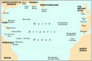
100 - North Atlantic Ocean Passage Chart, 1:7,620,000 - At a scale of 1:7,620,000 this chart covers the North Atlantic from Brazil to Newfoundland and Gibraltar to the Caribbean. It has been constructed on a conical projection which means that Great Circle tracks can be plotted as straight lines rather than curves. The chart shows the main trend of contours, limits of ice, magnetic variations and keys routes as identified by D. M. Street. On the reverse are notes on the routes and small wind rose charts, with accompanying charts showing excessive wave heights and storm frequencies month by month. Chart 100 is an important companion for Atlantic yachtsmen on passage and an excellent source of planning information.
Imray Iolaire E Series Charts for the Atlantic Islands
Imray Iolaire Charts for the Atlantic Islands provide coverage of popular areas on sheets especially designed for the needs of yachtsmen. Many of the charts in the series now include sailing directions on the reverse side.
Each Imray lolaire Chart provides ideal coverage of familiar cruising grounds at workable scales. Large scale plan inserts cover harbours and anchorages in detail. A single Imray lolaire Chart does the work of several of its rivals.
Produced by Imray Laurie Norie & Wilson Ltd in the United Kingdom, publishers of nautical charts since the 18th century. Imray lolaire Charts were first launched in 1979 and are produced to the high standard that has come to be associated with the oldest private chart publisher in the world.
Each sheet is printed on durable waterproof paper, which is ideal for charter boats where wear and tear is considerable.
E1 - Arquipelago dos Açores, 1:750 000 - Plans included: Vila das Lajes, Horta, Lajes (Pico), Porto das Velas, Vila da Praia, Praia da Vitória, Angra do Heroísmo, Ponta Delgada, Vila Franco do Campo, Vila do Porto. 2011 Edition - Fully updated throughout. This edition shows extensive harbour developments (including new marinas) on the Vila das Lajes, Horta, Porto das Velas, Vila da Praia, Praia da Vitória and Ponta Delgada plans. The inset for Vila Franco do Campo has been redrawn with new survey data and is now fully WGS84 compatible. In addition, a new plan of Lajes (Ilha do Pico) has been added in place of Madalena.
E2 - Islas Canarias, 1:600,000 - Plans included: Puerto de Santa Cruz, Puerto de la Estaca, Puerto de San Sebastian de la Gomera, Darsena de Los Llanos (Marina Santa Cruz), Darsena Pesquera (Marina Tenerife), Puerto de las Palmas, Morro Jable, Marina Rubicon, Puerto Calero, Estrecho del Rio. 2011 Edition - Fully updated. Includes changes to depths and coastline at Dársena de los Llanos and Dársena Pesquera. The Puerto de las Palmas plan has been extended and fully updated to show the extensive harbour developments. In addition, a new plan of Puerto Calero replaces the Puerto del Rosario plan.
E3 - Arquipelago da Madeira, 1:170,000 - Plans included: Porto Santo, Porto de Recreio de Calheta, Funchal, Ponta de Sao Lourenco, Quinta do Lorde, Enseada da Doca (Isla Deserta Grande), Porto de Machico, Agua de Pena. Plans on reverse of chart: Selvagem Grande, Selvagem Pequena. 2011 Edition - Extensively reschemed to include new plans of Quinta do Lorde, Enseada da Doca, Porto de Machico and Agua de Pena. Sailing directions have been added to the reverse of the chart, as well as plans of Ilhas Selvagens.
E4 - Arquipelago de Cabo Verde, 1:500,000 - Plans included: Porto Novo (Ilha de Santo Antão), Porto Grande (Ilha de São Vicente), Ilha de Santa Luzia, Porto de Tarrafal (Ilha de São Nicolau), Porto da Preguiça (Ilha de São Nicolau), BaÍa da Palmeira (Ilha do Sal), Porto de Sal-Rei (Ilha da Boavista), Porto da Praia (Ilha de Santiago), Cavaleiros (Ilha do Fogo), Porto da Furna (Ilha Brava). 2011 Edition - This is a brand new, digitally drawn edition of the chart, offering improved clarity and enhanced definition of detail.
E5 - Bermuda, 1:60,000 - Plans included: St George's Harbour, Dockyard Marina, Hamilton Harbour, Bermuda Approaches (on reverse). 2012 EDdition - Fully updated with the latest known depth surveys and harbour developments. A new Approaches to Bermuda plan has also been added to the reverse.
100 - North Atlantic Ocean Passage Chart, 1:7,620,000 - At a scale of 1:7,620,000 this chart covers the North Atlantic from Brazil to Newfoundland and Gibraltar to the Caribbean. It has been constructed on a conical projection which means that Great Circle tracks can be plotted as straight lines rather than curves. The chart shows the main trend of contours, limits of ice, magnetic variations and keys routes as identified by D. M. Street. On the reverse are notes on the routes and small wind rose charts, with accompanying charts showing excessive wave heights and storm frequencies month by month. Chart 100 is an important companion for Atlantic yachtsmen on passage and an excellent source of planning information.
We use cookies and similar tools that are necessary to enable you to make purchases, to enhance your shopping experiences and to provide our services, as detailed in our Cookie Policy. We also use these cookies to understand how customers use our services (for example, by measuring site visits) so we can make improvements.
If you agree, we’ll also use cookies to complement your shopping experience as described in our Cookie Policy. This includes using first- and third-party cookies, which store or access standard device information such as a unique identifier. Third parties use cookies for their purposes of displaying and measuring personalised ads, generating audience insights, and developing and improving products. Carry on browsing if you’re happy with our Cookie Policy, or find out how to manage your cookies. To learn more about how and for what purposes we use personal information, please visit our Privacy Notice.

 Imray Iolaire E Series Charts for the Atlantic Islands
